Some background:
(TL;DR: Scroll down for the Google Earth live preview)
For those of you who haven’t heard of the Big Bang Theory, it’s this show about this group of friends and how they live with their quirky behaviours and stuff, standard fare there. Kinda like Friends, and How I Met Your Mother. But what’s so awesome about this show is that it manages to tie in popular sci-fi (think Star Wars, Star Trek, comic books, yada yada) and actual science (quantum physics, kinetic and mechanic theory, molecular biology, neurophysics, hyperdrive theory) with the lives of these guys. This show has grown to be legendary among geeks, comic book fans, sci-fi fans and others alike. Myself included, obviously.
So anyway in the Season 5 finale, (spoiler alert!) Howard and Bernadette get married on the rooftop of Leonard and Sheldon’s house, and they timed it to coincide with the passing of the Google satellite over their location in Pasadena. Even had the whole zoom-out-from-ground-to-space scene, which was pretty darn cool.
Me being the Google addict I am, I just had to Google it to see if it really got captured by Google Earth. Now before you laugh at me for thinking a fictional show could be experienced in real life, consider that all the websites mentioned on How I Met Your Mother (www.barneysvideoresume.com, www.itwasthebestnightever.com, www.canadiansexacts.org, www.notafathersday.com and www.tedmosbyisajerk.com) are all real – so I really wanted to know whether Big Bang Theory was *that* awesome to get Google Earth to do this for real.
Here’s the scene (MEGA SPOILER ALERT! Don’t watch if you haven’t seen the episode!):

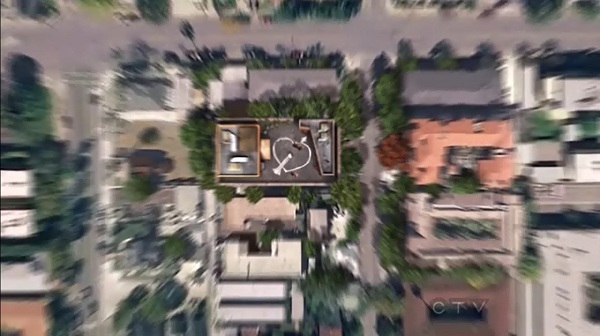
And here’s the frame of the initial zoom-out:
And here it is on Google Earth:
Sadly as you can see… it’s not there 🙁 Too bad then. Well at least I don’t have to continue wondering, and now you don’t have to as well 🙂
Hope you enjoyed the series as much as I did, and I certainly look forward to the next season! Thanks for reading!


17 Responses
Hi,
You didn’t examine the images very well. Date of broadcast in US: 10th of May 2012
Images on Google Earth 8th of March 2011. So it couldn’t be there yet.
Ah yeah now that you mention it, that’s indeed a loophole right there, thanks! I suppose we’ll just have to wait a few years for Google to refresh that part of Maps huh?
Ah yeah now that you mention it, that’s indeed a loophole right there, thanks! I suppose we’ll just have to wait a few years for Google to refresh that part of Maps huh?
Also the image you took from Google Maps (not Google Earth 😉 ) is not a picture from a satelite but from a fly over by a plane. If you’re using google maps instead of google earth and you zoom in very close it switches from the one source to the other.
We know that if this had happened in “How I met your mother”, it would appear on google maps/earth. The creators of that series have done so many details, like creating all the websites that are mentioned in the show.
I was disappointed when TBBT mentioned a youtube video of an astronaut screaming for hours… They should’ve done it, at least as a viral advertisement (maybe loop it so that it actually is hours long). But oh well…
Guy’s those are not the same buildings. Try comparing the two photos. Not even close….
Those are the same buildings… way to look closely.
Hey Bro! Times changed and buildings changed too but if you look at the right side of the pictures you can see the same houses
The buildings look close but TBBT building has more stuff on the roof such as a storage closet.
The Big Bang appartment is at 2311 N. Los Robles Avenue…
So….is there a way to know where the Google satellite is, so we can be outside when it goes over, like they did, in the show?
There isn’t an actual Google satellite per se. Google purchases images from a variety of different sources that operate many various geo scanning satellites from several NASA, NOAA and DoD sources, as well many companies that provide sevices for the energy and mining corporations.
Really interesting what you are saying but you didn’t answer his question.
He did, sort of. Basically Google doesn’t stream satellite feeds like in TV – they buy pre-taken satellite pictures by a host of other sources and stitch it up together. So no, there’s no way to know where the satellite will be at any time unless you have extraordinary resources.
No he did not.
He explained what resources google uses.
it seems very likely that google knows when a nasa satelite is passing your neighbourhoood.
so it could be the case that google releases the data when the satelite is going to pass by.
that is not their satelite doesn’t mean they dont know when it will be where
a good example of an answer would be:
no you can’t know this because google doesn’t know when the satellites are going to shoot images because the satelites are not theirs but from companies like nasa.
or:
no you cant know this because google has stated they don’t want to release this information this information because it would be used in bad ways
Ohh. You’re one of those. Okay.
what do you mean with one of those? I only told to you why I believe he did not answer the question.
Did I say something wrong?